Why Communication and Navigation Are Critical for Survival and Emergencies
J.T. Wilder | Survival strategist, Survival Tactix | Last updated: July 1, 2026
When the power goes out, a storm cuts off cell service, or a day hike takes a wrong turn, two things decide how the next few hours go. Can you reach someone, and do you know where you are? Communication and navigation are not gadgets you buy once and forget. They are a working system, one that should hold up even when phones die, towers overload, or trail markers disappear. This guide covers what actually works and what the FCC and Canada’s ISED require before you transmit on a radio. It also shows how to build a simple, honest communication-and-navigation kit for your household or your pack.
Fast track: Start with a family communication plan and one licensed-appropriate radio, then add offline maps and a backup locator device as budget allows.
Get the 72-Hour Checklist (email) Check gear prices (hub)
Disclosure: As an Amazon Associate, SurvivalTactix earns from qualifying purchases. This supports the site at no extra cost to you.
Preparedness information is for general education. Radio licensing rules differ by country and change over time, so confirm current requirements with the FCC (US) or ISED (Canada) before transmitting. For medical or legal questions, consult a qualified professional.
Jump to: Quick answer • Why it matters • Phone satellite SOS • Communication tools • Radios & licensing • Navigation tools • Quick picks • Canada notes • Building a kit • Mistakes to avoid • Resources • FAQ
Quick answer: what should most people carry?
Most households need three layers: a way to reach family and emergency services (phone plus a simple two-way radio), a way to receive official alerts (see our emergency radio guide for weather-radio picks), and a way to navigate without cell signal (offline maps plus a physical map and compass). Add a satellite messenger only if you regularly travel outside cell coverage.
Why communication and navigation matter in a real emergency
Food, water, and shelter get most of the attention in preparedness content. However, a household that cannot reach help or find its way home is still in danger even with a full pantry. Communication lets you call for help, coordinate with family, and receive official warnings. Navigation keeps you from making a bad situation worse by wasting time, energy, or daylight while lost or disoriented.
In practice, both problems show up together. A power outage knocks out landlines and routers. A regional disaster overloads cell networks so calls fail even though towers are standing. A hiking trail loses its markers after a storm. In each case, the fix is the same: have a plan and tools that do not depend entirely on the grid working perfectly. The most extreme version of “the grid not working” is an electromagnetic pulse or major solar storm: see our EMP survival expert interview for how to shield and diversify your communications for that scenario.
Can your phone handle it? Satellite SOS in 2026
This is the part of the picture that changed fastest, and most older guides have not caught up. As of 2026, satellite emergency messaging is standard on newer phones, not a niche accessory. iPhone 14 and later models support Emergency SOS via satellite at no extra cost, and recent Google Pixel and Samsung Galaxy models offer similar satellite SOS or messaging depending on carrier. Apple’s own guidance explains how the feature works and its limits.
That said, phone-based satellite SOS has real limits. It needs a clear view of the sky, it is slower than normal texting, and battery life becomes the bottleneck once the grid is down. Because of that, a phone with satellite SOS is a strong first layer, not a replacement for a charged power bank, a dedicated satellite messenger on longer backcountry trips, or a simple radio at home. Check your specific phone model and carrier before you rely on this feature, since satellite support and coverage continue to expand and vary by carrier.
What communication tools should you actually carry?
A workable communication layer does not need to be complicated. Start with the tools that work without a subscription, then add range and redundancy as needed.
Two-way radios: FRS, GMRS, and HAM, explained honestly
Most consumer walkie-talkies sold for camping and family use are FRS (Family Radio Service) radios. In the United States, FRS radios are license-free by design, work out of the box, and are the right starting point for most households. GMRS (General Mobile Radio Service) radios offer more power and longer range, and the FCC requires a GMRS license to transmit legally. That license currently costs about $35, lasts 10 years, and covers your entire immediate family under one call sign, with no test required. See the FCC’s GMRS overview for current rules.
One honest note competitors often skip: popular budget transceivers marketed for “survival radio” use, like the Baofeng UV-5R, are amateur (HAM) radios. Transmitting on FRS or GMRS frequencies with a radio that is not Part 95-certified for that service is not legal, and HAM bands require a separate FCC Technician license and exam. If you want the simplicity of grab-and-go family radios, buy an actual FRS/GMRS radio. If you want the range and flexibility of HAM radio instead, plan to study for the Technician license first, since it is a worthwhile skill but not a shortcut.
For staying informed rather than talking to your group, a dedicated weather radio matters more than a two-way radio. Our emergency radio buying guide covers NOAA weather-radio features, solar and hand-crank tradeoffs, and specific picks for US and Canadian households.
Whistles and signal mirrors: simple tools that never need a battery
An emergency whistle is one of the highest value-per-dollar items in any kit. A quality whistle can be heard much farther than shouting, does not strain your voice, and keeps working after hours of use. Pair it with a signal mirror for daytime visual signaling to aircraft or distant search teams. Neither tool needs power, a subscription, or a license, which makes them a smart backup no matter what else you carry.
Satellite messengers and personal locator beacons
Once you travel outside cell and satellite-SOS coverage regularly, a dedicated device becomes worth the cost. Backcountry hiking, remote hunting, and off-road travel are common examples. Two categories exist, and they solve different problems. A personal locator beacon (PLB), such as the ACR ResQLink line, sends a one-way distress signal over the international COSPAS-SARSAT system with no subscription fee, just a one-time purchase. A satellite messenger, such as a Garmin inReach or ZOLEO device, adds two-way texting, location sharing, and non-emergency messaging, but requires an ongoing subscription plan.
If your main concern is a true worst-case rescue and you want to avoid recurring costs, a PLB is the simpler choice. If you want to check in with family, get weather updates, and send routine messages from the backcountry, a satellite messenger earns its subscription cost. Compare current plans directly with the manufacturer before buying, since pricing changes.
How do you find your way without GPS or cell service?
Navigation tools solve a different problem than communication tools: not “can I reach someone,” but “do I know where I am and where I’m going.” A layered approach works best here too.
Map and compass: the skill that never runs out of battery
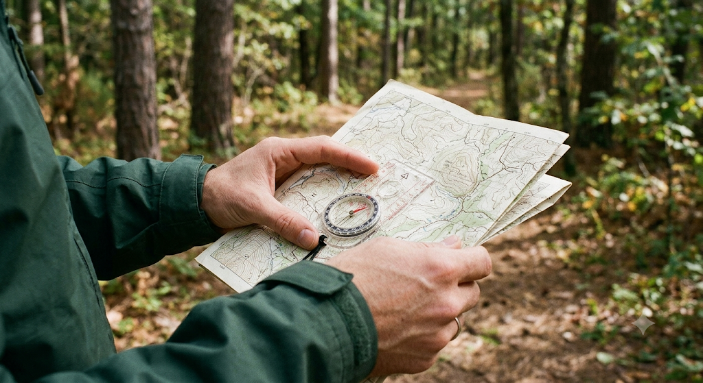
A paper topographic map and a baseplate compass remain the most reliable navigation tool in existence, because they need no signal, no charge, and no subscription. The one skill most people skip is adjusting for declination, the difference between magnetic north (where your compass points) and true north (where your map is oriented). Skipping this adjustment can put you a meaningful distance off course over a multi-mile route. NOAA’s online declination calculator gives you the correct value for any location before you head out, and most outdoor retailers can show you how to set it on your specific compass model.
Offline map apps: your phone’s best backcountry feature
Modern hiking apps such as Gaia GPS and AllTrails let you download detailed topo maps before you lose signal. From there, the app tracks your GPS position on that downloaded map with zero cell connection required. This works because GPS positioning itself does not need cell service; only the map tiles need to be downloaded in advance. Download your route’s maps the night before any trip, and treat the app as a companion to a physical map and compass rather than a full replacement, since phone batteries fail and screens crack.
Quick picks: communication and navigation gear worth having
These are gear categories, not specific model endorsements. Always check current reviews and specs before buying.
- FRS/GMRS two-way radio (family set): Check price (US) • Check price (Canada)
- Emergency whistle and signal mirror combo: Check price (US) • Check price (Canada)
- Baseplate compass with adjustable declination: Check price (US) • Check price (Canada)
- Satellite messenger / personal locator beacon: Check price (US) • Check price (Canada)
- Waterproof topo map case: Check price (US) • Check price (Canada)
For weather-radio specific picks, see the full emergency radio buying guide.
What Canadian readers should know
Canada’s rules differ from the US in a useful way. Under Innovation, Science and Economic Development Canada’s (ISED) spectrum policy, both FRS and GMRS radios are license-exempt for personal use, provided the device is certified and used within standard power limits. There is no $35 fee and no repeater use for GMRS in Canada, unlike the US. See ISED’s official spectrum policy for the current rules. For weather alerts, Environment Canada’s Weatheradio service has been discontinued in most regions, so prioritize official alert apps and strong AM/FM reception. Our emergency radio guide covers this in more detail.
Building a simple communication and navigation kit
Layer your kit instead of buying everything at once:
- Everyone: a written family communication plan, a charged phone, and an emergency whistle
- Families with school-age kids: extend the plan to the school day: see our back-to-school family emergency plan for pickup failures, home-alone readiness, and school lockdowns
- Households: add an FRS/GMRS radio set and a weather radio (see our radio guide)
- Hikers and travelers off the grid: add a baseplate compass, downloaded offline maps, and a signal mirror
- Backcountry regulars: add a PLB or satellite messenger, and consider a HAM Technician license for wider range
This same layered logic applies across your broader preparedness plan and connects directly to your 72-Hour Emergency Kit.
Common mistakes to avoid
- Transmitting on GMRS/FRS frequencies with an unlicensed HAM radio: it is not legal in the US, even if the radio physically can do it
- Relying on one tool: a single point of failure defeats the purpose of a communication layer
- Skipping declination when using a compass: a small angle error compounds over distance
- Downloading offline maps at the trailhead instead of before you leave: by then it may already be too late if signal is gone
- Assuming satellite SOS on your phone works anywhere: it still needs a clear sky view and a charged battery
- Never testing gear before an emergency: the first time you use a radio or compass should not be during a crisis
Trusted resources and related guides
Trusted external resources
- Ready.gov: Make a Family Communication Plan
- FCC: General Mobile Radio Service (GMRS) overview
- NOAA Weather Radio: Official overview
- ISED Canada: FRS/GMRS spectrum policy
Related SurvivalTactix guides
- Emergency Radio with Solar and Hand Crank
- Being Prepared for Emergencies
- 72-Hour Emergency Kit Gear Hub
- Natural Disaster Survival: The Complete Guide
- Cold Weather Survival
- “Always Be Ready”: An Expert Interview
You Don’t Need Every Gadget to Be Ready
It’s easy to look at a full communication-and-navigation kit and feel like you’re starting from zero. You’re not. A written family plan and a five-dollar whistle already put you ahead of most households. Pick one gap to close this week, whether that’s downloading offline maps for a route you drive often or finally writing down your out-of-area contact. Add the next layer when it fits your budget and your life. Small, steady upgrades add up faster than people expect, and there is no prize for doing it all at once.
A Word of Encouragement
Communication and navigation can look like the most technical corner of preparedness, and that puts a lot of people off starting at all. It shouldn’t. A charged radio, a paper map of your own area, and one agreed meeting point cover an enormous amount of ground. Begin there, and add the more advanced tools only if your situation genuinely calls for them.FAQ
Do I need a license to use a walkie-talkie for camping?
No. Standard FRS radios are license-free in both the US and Canada. A GMRS license is only required in the US, costs about $35, and covers your whole family for 10 years.
Is the Baofeng UV-5R legal to use for family communication?
It is a HAM radio, not an FRS/GMRS-certified device. Transmitting on FRS or GMRS frequencies with it is not legal in the US. Use an actual FRS/GMRS radio for family use, or get a HAM Technician license if you want that radio’s range.
Does my phone’s satellite SOS feature replace a satellite messenger?
For occasional use near cell coverage, it can cover most needs. For regular backcountry travel, a dedicated satellite messenger or PLB offers more reliable coverage and, in the case of messengers, two-way texting.
What’s the difference between a PLB and a satellite messenger?
A PLB sends a one-way distress signal with no subscription fee. A satellite messenger adds two-way texting and check-ins but requires an ongoing plan.
Do I really need to adjust my compass for declination?
Yes, if you’re navigating any real distance. The error is small in degrees but grows the farther you travel, and it’s a one-time adjustment for each region you visit.
What’s the simplest communication and navigation setup that actually works?
A written family communication plan, a charged phone, an emergency whistle, and offline maps downloaded before you leave. Everything else is a worthwhile upgrade, not a requirement to get started.
Next step
Start with a family plan, a whistle, and offline maps for the routes you already travel. Add a radio, then a satellite messenger, as your needs and budget grow.